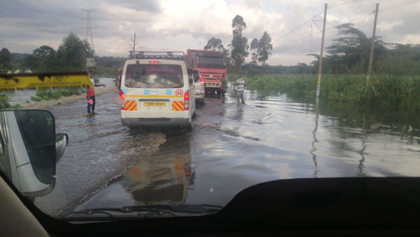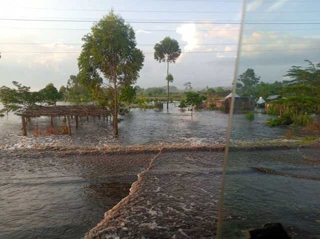
Masaka, Uganda | THE INDEPENDENT & URN | Drivers are seeking alternative routes through the villages today when floods cut off Kampala-Masaka highway in central Uganda after River Katonga burst its banks. There were increasing fears that the floods will also affect key bridges at Lwera on the same road.
Kampala-Masaka highway is one of the busiest roads in the country with an estimated average daily traffic count of over 30,000 vehicles. The road is the main gateway to Tanzania, Burundi, Rwanda, and the Democratic Republic of Congo handling major cargo to and from.
Travelers from Kampala to Masaka have been advised to use the Mpigi – Butambala – Ssembabule road as an alternative to get to Masaka.
In a statement, Uganda National Roads Authority (UNRA) said “We have reports of flooding at Katonga section on Masaka Road. Our teams are assessing the situation and exploring possible interventions & diversion routes. For now, we STRONGLY advise road users to exercise extreme caution when approaching this section.”
“We urge motorists from Kampala to Masaka to DIVERT and use Mpigi—Kanoni—Maddu—Ssembabule—Masaka, and vice versa for those from Masaka—K’la as we allow water levels to subside.”
Water levels rise
The water levels have risen considerably in recent days, posing a significant danger to both motorists and pedestrians attempting to cross. On Thursday, videos and photos emerged showing slow traffic movement at a section of the road where waters were overflowing onto the road.
Lydia Tumushabe, Katonga Region Police Spokesperson said that in a bid to ensure the safety of road users, they have been advised against using this section of the road at present.
“We strongly advise using alternative roads as we collaborate with Uganda National Roads Authority-UNRA to address the situation promptly…please exercise caution, follow traffic instructions, and watch out for updates,” Tumushabe stated.
📡 Aerial footage captures the extent of flooding at Katonga along Kampala—Masaka road.
Regrettably, the level of flooding at this section continues to rise.
To avoid any potential inconveniences, please divert to the safer route via Mpigi—Kanoni—Ssembabule—Masaka road. pic.twitter.com/J0teJIq2Uq
— UNRA_UGANDA (@UNRA_UG) May 11, 2023
According to Allan Ssempebwa, the Spokesperson for UNRA, due to severe flooding at a section of the road, motorists traveling from Kampala to Masaka should use the recently constructed Mpigi-Kanoni-Maddu-Ssembabule-Masaka road, while those traveling from Masaka to Kampala should do the same in reverse.
“The diversion will remain in place until the water levels have sufficiently subsided,” Ssempebwa noted.
The Mpigi-Kanoni-Ssembabule-Masaka route spans a total of 184km, which is almost double the distance of the direct route from Mpigi to Masaka, which is only 93.7km. As a result of this diversion, transport fares on the route are likely to increase, which will negatively affect travelers.
Additionally, the transportation of goods may also be delayed due to the longer distance, causing further inconvenience and expense.

In the past five years, several sections of this road, from Mpigi to Kalungu district, have been breaking down more prominently towards Christmas and Easter holidays, not only paralyzing transport but also putting the lives of hundreds of people plying the road on a daily basis at risk.
While it is common for several swamp sections of various roads to experience flooding during the rainy season, the current situation of flooding and damage to different sections of Masaka Road is attributed to continuous sand mining, rice growing, and other agricultural activities in the area.
According to reports, these activities have altered the (physical appearance of the land) and hydrology (the distribution and movement of water both on and below the Earth’s surface) by digging trenches in the spacious swamp that connects directly to Lake Victoria, leading to the current situation.
Some years back engineers from UNRA, examined this section of the road and pointed out that the two activities have been leading to a decrease in how soils in the area hold or let water move. They noted that the wetland no longer holds water, resulting in flooding whenever it rains.
In recent days, flooding has also affected other sections in Lwera, Kamuwunga, and Lukaya as several streams in the area burst their banks following heavy rainfall.
Despite the National Environment Management Authority (NEMA) issuing a warning about the dangers of continuous sand mining and rice growing in the Lwera wetland to transportation along the Kampala-Masaka highway, they have controversially defended the continuation of these activities.
For sand mining, investors have stationed dredgers in the middle of the wetland and scooped up tons of sand from an area covering more than 100 kilometers across the highway, going more than 10 meters deep underneath the swamp. These activities create open pits that are always filled with water, leading to frequent flooding of the road.
In a recent interview with Eng. Lawrence Pariyo, the Head of Bridges and Structures at UNRA, revealed that they are currently re-engineering the affected section of the road to find a lasting solution. He also hinted at the possibility of raising some sections of the Lwera wetland with bridges, as well as the reconstruction of the Katonga bridge.
These measures are aimed at mitigating the impact of heavy rains and flooding on the road, thereby improving safety for motorists and pedestrians.
*******
RELATED STORY
 The Independent Uganda: You get the Truth we Pay the Price


sitya danger awo mpitawo
Now the government should atleast hurry and work on that road seriousely man
Now the government should now hurry to work on that road seriosely