What can be done to mitigate the effects
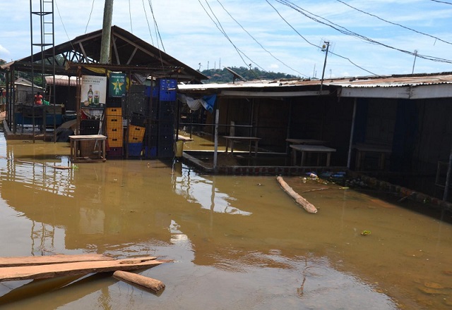
| LYDIA OLAKA | In recent weeks, water levels in Lake Victoria have reached unprecedented heights as a result of heavy rains in the East African region which started in August 2019. Some say the lake’s levels have not been this high for 50 years. According to the Lake Victoria Basin Commission, the lake hit a new record level of 13.42 meters – marginally higher than the 13.41 meter mark recorded in 1964.
Nestled between Rwanda, Burundi, Uganda, Kenya and Tanzania, Lake Victoria supports the livelihoods of over 35 million people and is crucial for many sectors. The rising water levels have been devastating, particularly for those that live close to the lake and depend on it.
The lake supports fisheries, agriculture (through providing irrigation), hydropower (mainly for Uganda), domestic water supply and industry.
The lake is also an important tourist destination and provides the habitat for many key species – such as endemic cichlid fishes, birds and sitatunga antelopes.
Because of the floods, it’s been reported that over 200,000 people have been displaced in Kenya, Uganda and Tanzania.
The floods have destroyed infrastructure, farmland and crops, and property around the lake. They have also increased the spread of pollution. This is increasing water treatment costs and affecting those living in the surrounding areas. There are now concerns that there will be outbreaks of vector borne diseases – such as malaria and bilharzia – and gastrointestinal diseases such as cholera.
Heavy rains
The rains the region received were unusually heavy and attributable to the Indian Ocean Dipole – a weather phenomenon caused by differences in sea surface temperatures between the eastern and western tropical Indian Ocean. Last year, the differences in temperatures were higher than usual, causing much more rainfall over East Africa from September to January.
Though the rains caused by the dipole have ended, the region then moved into its rainy season which typically runs from March to May.
Lake Victoria has an enormous surface area of 68,800sqkm. Rainfall is very important for the lake as it accounts for 80% of its recharge. The 23 rivers that recharge the lake account for only 20% of its input.
From research my colleagues and I have done – examining the projected changes in weather in the Lake Victoria basin – we’ve found that these high water levels will be more frequent in the future because there’ll be much more rainfall.
The aim of our study was to look at how the rivers that drain into the Lake Victoria basin will change as a result of increased greenhouse gases in the atmosphere.
We show that, between 2036 and 2065, there will be 25% more annual rainfall in the eastern part of the lake Victoria catchment (Kenya and Tanzania side) area and between 5 and 10% in the western part of the catchment (Rwanda and Burundi side).
Our models use data from the Rossby Center Regional Atmospheric Model along with the global climate model from the Coordinated Regional Climate Downscaling Experiment project.
We coupled this with information on how much greenhouse gas there could be in the future. There are a series of scenarios – known as Representative Concentration Pathways – which represent what could happen in the future based on different emission trajectories. The more pessimistic scenarios, for instance, assume that no climate change policies are implemented and so there is an increase in greenhouse gases. These, more pessimistic, scenarios are what we based our models on.
Our data shows how much rain there could be. Lake Victoria is an open lake meaning whenever the lake level rises, spill-off should occur – this makes it hard to predict how much the lake will rise because the control of the spillover is through manmade dams in Jinja, Uganda.
When the lake’s levels do get high, there are measures that countries affected can take– but they are not easy. They require careful planning and availability of funds.
What can be done
It’s all about managing the inputs and outputs and developing floodplain regulations.
The first step will be to plan how to reduce the flow of water into the lake by creating storage within the catchments – such as dams or reservoirs – or finding ways to divert the water – for instance through the use of canals or spillways.
However this will only manage 20% of what goes into the lake, as most of the recharge is because of rainfall. So we need to also consider outputs.
The only surface outlet of the lake is through the Victoria Nile River which forms the upper section of the Nile River. The Kiira and Nalubale dams, in Jinja, control the outflow of Lake Victoria into this river. Dam management scenarios that regulate the outflow to mimic natural lake level fluctuations are needed.
There are currently tensions over this, as there are accusations that Uganda could have done more to prevent the current floods by regulating the dams better. More must be done to ensure this does not happen again and that countries have strict agreements in place.
In addition to managing the lake’s levels through inputs and outputs, it’s extremely important that the region increases investments in monitoring systems that provide national early warning and communication. This will alert residents in a timely manner.
****
Lydia Olaka is a Lecturer, University of Nairobi
Source: theconversation
 The Independent Uganda: You get the Truth we Pay the Price


